Introduction

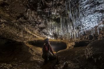
Crag Cave, Co. Kerry. © R. Mulraney
The database contains essential information, length, depth, grid reference, altitude etc, on caves in the island of Ireland. The main project map is not yet complete. It covers most of the western and southern part of the island and will be added to as more data becomes available.
The database is fully searchable, both by text and by map, from the search page linked to above. There is also a browsable map, a facility for browsing county by county and a glossary explaining the fields displayed for each entry.
There are a few sites recorded which are not shown in the database, as no location information exists for them. What is known about them is listed here.
We continue to maintain one GIS map, for Co. Clare, as this displays cave passages as well as entrances. It may be found by following this link.
Disclaimer
The database and maps contain information that has been collected and collated over a long period of time from many different sources. The Society makes no claim as to the accuracy or completeness of these records. The use of the information is free to all, under this Creative Commons Licence, but the Society accepts no responsibility for how the content is used. The Society cannot and will not respond to specific enquiries about specific properties or parcels of land. The Society is not able to provide any form of service for house buyers or sellers, their surveyors or their legal representatives nor can the Society assist with the interpretation of the information contained here.
